GIS IQ Blog
  • Schule
  • Hochschule
  • Forschung
Kategorien
  • Forschung
  • Hochschule
  • Schule
Themen
ArcGIS Case Studies Digitale Bildung Dozierende eduGISchat Events GeoDev KarriereMitGIS Kartografie Lehrerhandreichungen Open Data Praktikum Projekte Ressourcen Schüler Smart Campus Smart Community Sommercamps Story Map Studierende Tutorial Unterricht Wettbewerb
  • Schule
  • Hochschule
  • Forschung
News
  • Hochschule

Creating a Smart Interactive Campus Map for Technische Universität München

  • 7. April 2015
  • Jan Wilkening
Total
0
Shares
0
0
0
0
0
0

Unser heutiger Gastbeitrag stammt von Abdelrahman Hussein, Vikram Devi Eswaramoorthy und Chiyuan Gu. Die drei studieren im International Master Programme in Cartography an der TU München und haben sich im vergangen Semester mit der Erstellung einer smarten, interaktiven Campus-Karte beschäftigt.


The project idea

The main idea of the project was to create a smart and interactive campus map for the main campus of Technische Universität München (TUM). The project went through different phases:

  • Evaluation of the existing technologies that might have been used as a platform for the project
  • Selection of the most suitable technologies that match the project requirements
  • Implementation of an initial version of the campus map web application and mobile application


Project requirements

The final version of the application had to fulfill the following requirements:

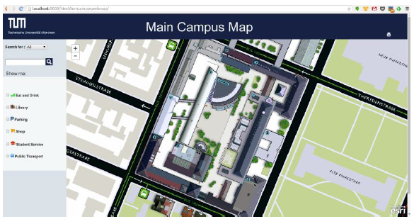
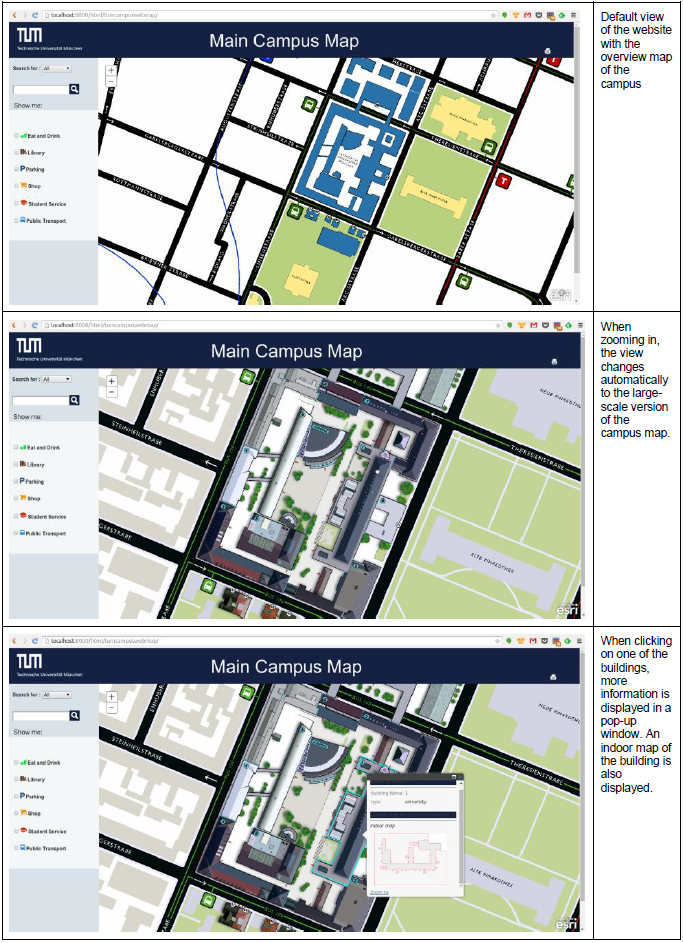
  • Integration of a large-scale map and an overview map in the web application and the mobile application
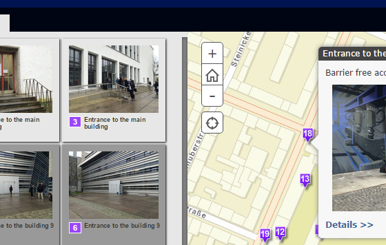
  • Implementation of interactive features including the possibility to change the map depending on the zoom level and to show indoor maps
  • Implementation of a simple web design that allows for more interactive features like layer control and search points of interest


Final version

This is how the final version of the website looks like:

Technologies

One of the goals of the project was to explore the most common technologies for creating web maps and to evaluate which set of technologies and frameworks the group should use. We spent quite some time exploring and testing the following frameworks:
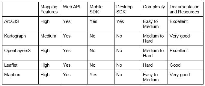
● ArcGIS
● Kartograph
● OpenLayers
● Leaflet
● Mapbox
We registered the results of our evaluation in the following matrix*:
Eventually, we decided to use the ArcGIS platform to implement both the web and the mobile application of the campus map.

ArcGIS technologies

We used the following technologies of the ArcGIS platform:
  • ArcMap – Serves for creating the map and geo-referencing the raster images for the overview and the detailed map with the basemap from OSM.
  • ArcGIS Online – Serves for creating a web map and hosting a published tile package containing the geo-referenced overview and detailed raster images.
  • ArcGIS Runtime SDK for Android – Serves for developing the mobile application version of the campus map for Android devices.
  • ArcGIS JavaScript SDK and APIs – Serve for using the map services published on the ArcGIS Online platform and integrating them in the campus map website.
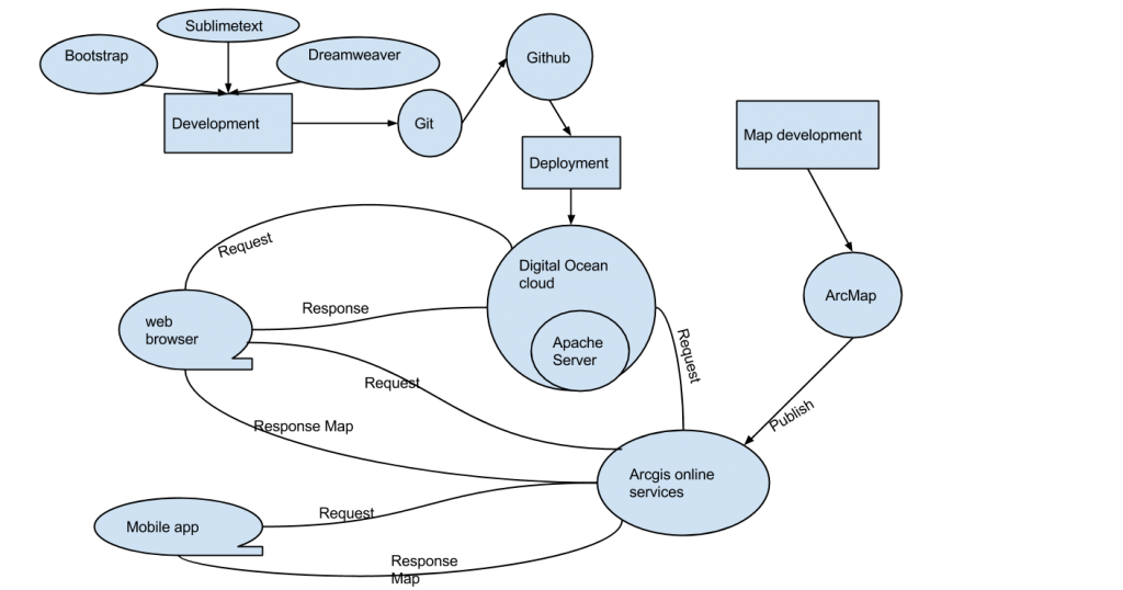
How it works

The following diagram shows a typical workflow that served for developing both the web application and the mobile application using the different technologies.

Conclusion

The ArcGIS technology provided us with a set of tools and frameworks that cover all our needs concerning server-side as well as client-side technologies and frameworks: from ArcMap for creating and publishing the services, via ArcGIS Online to develop the mobile app using the SDK for Android devices, to the ArcGIS API for JavaScript for eventually enabling the client to use all these services.

*Note:

The assessment was carried out by the authors of this post within the scope of their project. Therefore, the opinions expressed in this publication are those of the authors. They do not necessarily reflect the opinions of Esri Deutschland GmbH. 

Abdelrahman Hussein
Vikram Devi Eswaramoorthy
Chiyuan Gu
Students of the 1st semester of the International Master Programme in Cartography
Technische Universität München
Total
0
Shares
Share 0
Tweet 0
Pin it 0
Jan Wilkening

Nachdem ich 2007 mein Geographie-Studium in Bonn mit einer der ersten Diplomarbeiten zum Thema Geomarketing abgeschlossen hatte, zog es mich an die Universität Zürich. Dort habe ich mich in meiner Dissertation mit kartenbasierten Entscheidungen unter Zeitdruck beschäftigt und Statistik- und GIS-Kurse geleitet. Ab 2012 arbeitete bei der Esri Deutschland GmbH als Solution Engineer. Seit meiner Berufung zum Professor für Geodatenanalyse an der Hochschule Würzburg-Schweinfurt im Jahr 2019 unterstütze ich nebenberuflich das Education Team von Esri.

Voriger Artikel
  • Forschung
  • Hochschule

Erstellung eines Geoinformationssystems für das Blauhöhlensystem

  • 1. April 2015
  • Team Education
Weiterlesen
Nächster Artikel
  • Hochschule

Creation of a Technische Universität München Campus Accessibility Map Using Esri Story Maps

  • 14. April 2015
  • Jan Wilkening
Weiterlesen
Dir könnte auch gefallen
Wattenmeer bei Abendsonne
Weiterlesen
  • Hochschule

Komm mit in den Nationalpark Wattenmeer: Sommercamp für Studierende 2025

  • Team Education
  • 7. März 2025
Weiterlesen
  • Forschung
  • Hochschule

Wettbewerb: Esri Young Scholar Award 2025

  • Stefan Graf
  • 14. Februar 2025
Administration von ArcGIS Online an Hochschulen
Weiterlesen
  • Hochschule

Administration von ArcGIS Online an Hochschulen: Tipps & Tricks

  • Team Education
  • 28. Januar 2025
Weiterlesen
  • Forschung
  • Hochschule
  • Schule

Effiziente Lizenzierung von ArcGIS: Einrichtung und Vorteile von Single Sign-On (SSO) 

  • Team Education
  • 28. Januar 2025
Weiterlesen
  • Forschung
  • Hochschule

ArcGIS Pro aus ArcGIS Online herunterladen

  • Stefan Graf
  • 28. Januar 2025
Gruppenbild mit den Teilnehmenden des Sommercamps vor der Jugendherberger auf der Insel Föhr
Weiterlesen
  • Forschung
  • Hochschule

Entdecke GIS in Aktion: Das Esri Sommercamp 2024 auf der Insel Föhr feiert 17-jähriges Jubiläum

  • Team Education
  • 3. Januar 2025
Weiterlesen
  • Forschung
  • Hochschule
  • Schule

Esri Konferenz 2024 – Jetzt noch Ticket sichern!

  • Team Education
  • 4. November 2024
Weiterlesen
  • Hochschule

Erfolgreich studieren mit ArcGIS

  • Team Education
  • 23. September 2024
GIS IQ Blog
  • Über uns
  • Impressum
  • Datenschutz
Lernen. Forschen. Entwickeln. Mit GeoIntelligenz!

Gib dein Suchwort ein und drücke Enter.