GIS IQ Blog
  • Schule
  • Hochschule
  • Forschung
Kategorien
  • Forschung
  • Hochschule
  • Schule
Themen
ArcGIS Case Studies Digitale Bildung Dozierende eduGISchat Events GeoDev KarriereMitGIS Kartografie Lehrerhandreichungen Open Data Praktikum Projekte Ressourcen Schüler Smart Campus Smart Community Sommercamps Story Map Studierende Tutorial Unterricht Wettbewerb
  • Schule
  • Hochschule
  • Forschung
News
  • Forschung

A new GIS-based toolbox to boost prospectivity modelling

  • 17. Oktober 2019
  • Melanie Brandmeier
Total
3
Shares
3
0
0
0
0
0

With the spread and development of human civilizations there is a growing demand for raw materials and a need for successful mineral exploration. Machine-learning approaches have evolved rapidly and are applied successfully to many data science problems.

In a recent paper, we introduce a new toolbox for ArcGIS that provides the most up-to-date machine-learning algorithms for prospectivity modelling as well as several preprocessing and evaluation tools.

The integration into the ArcGIS platform allows a streamlined workflow for industry, from modelling to ground-truthing and mobile data collection in the field. This is achieved by synchronizing results with mobile apps such as Collector for ArcGIS to use results directly during fieldwork and to add data into the database.

The modelling approach can be knowledge- or data-driven. In the present study, we use purely data-driven models.

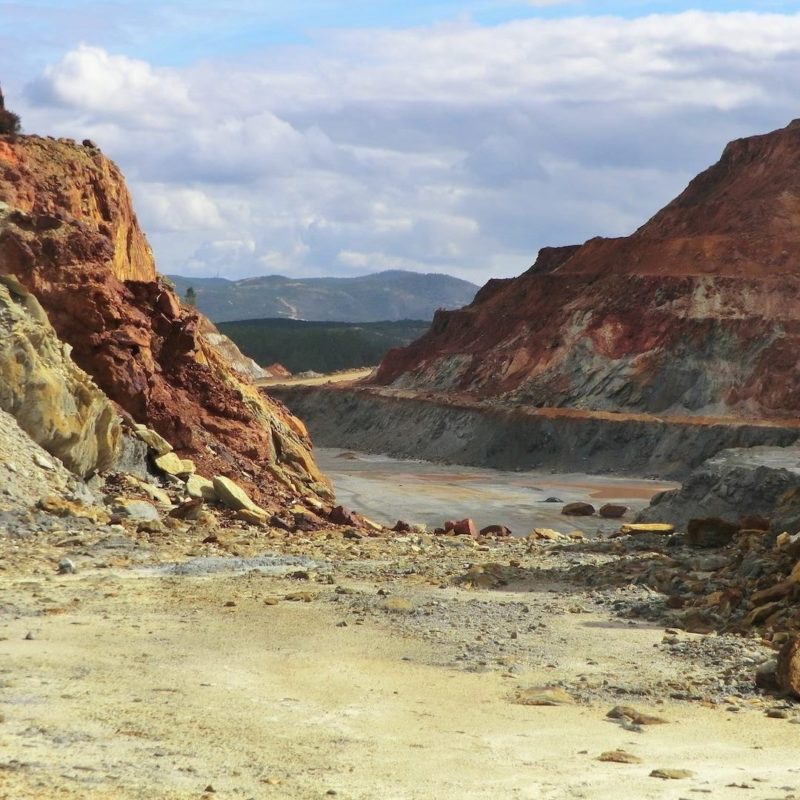
Besides algorithms like Support Vector Machines, Logistic Regression and Random Forests, Boosting algorithms were implemented and tested for performance, processing time and robustness on a dataset from the Iberian Pyrite Belt (IPB). The IPB is very well suited for testing the algorithms as there are many known deposits such as the mine of Río Tinto (Fig. 1) that can be used to train the algorithms.

Mine of Río Tinto

All machine-learning algorithms performed very well on the test data, especially the Boosting and Random Forest algorithms. The new tools are a good data-driven alternative to other methods for prospectivity modelling. Boosting algorithms can be easily applied due to only few parameters that need to be tuned and perform well even with only few samples to train on.

The full article is available as open-access publication and can be found here. The Experimental tools are included in a new version of the Spatial Data Modeler ArcSMD5 (https://github.com/gtkfi/ArcSDM) toolbox running on the ArcMap (10.4 and 10.5) and ArcPro.

Autoren: Melanie Brandmeier, Irving Gibran Cabrera Zamora, Vesa Nykänen, Maarit Middleton

Total
3
Shares
Share 3
Tweet 0
Pin it 0
Melanie Brandmeier

After finishing my studies of Geography, Geology and Geochemistry in Tübingen, I fulfilled my dream to do research the Andes of Latin America. My PhD topic was an interdisciplinary approach to understand ignimbrite distribution, eruption rates and compositions within the context of the Andean Orogeny. After finishing my Phd I worked as a Postdoctoral researcher at the Helmholtz Institute for Resource Technology in the field of mineral exploration. My work involved many different methods ranging from geochemical analysis and dating to GIS-based modelling and multisprectral remote sensing. I love to combine and analyse data and GIS is just the tool to do so:-)

Voriger Artikel
  • Schule

Daten für Schweizer Schulen: Thematische Datengruppen in ArcGIS Online

  • 4. Oktober 2019
  • Thomas Ingold
Weiterlesen
Nächster Artikel
  • Forschung
  • Hochschule
  • Schule

Video-Reihe: Dürre visualisieren

  • 25. Oktober 2019
  • Team Education
Weiterlesen
Dir könnte auch gefallen
Weiterlesen
  • Forschung
  • Hochschule

Geoinformatik Ingenieure – Computer Vision richtig lernen!

  • Team Education
  • 31. Januar 2023
Weiterlesen
  • Forschung
  • Hochschule
  • Schule

Esri Konferenz Mediathek ist live!

  • Team Education
  • 9. Dezember 2022
Weiterlesen
  • Forschung
  • Hochschule

#KarrieremitGIS: Was einen Sales Engineer ausmacht!

  • Stefan Graf
  • 2. Dezember 2022
Weiterlesen
  • Forschung
  • Hochschule

Imagery mit ArcGIS für Hochschulen

  • Fabian von Bechen
  • 9. November 2022
Weiterlesen
  • Forschung
  • Hochschule

Women@Esri Workshop: Baue eine interaktive 3D-App

  • Daniela Wingert
  • 13. Oktober 2022
EsriKon2022
Weiterlesen
  • Forschung
  • Hochschule

EsriKon 2022: Events für Studierende

  • Team Education
  • 26. September 2022
Weiterlesen
  • Forschung
  • Hochschule

Kostenloser Online-Kurs: «Transform Architectural, Engineering and Construction Projects with GIS and BIM»

  • Stefan Graf
  • 13. September 2022
Weiterlesen
  • Forschung
  • Hochschule

Masterarbeit: Augmented Reality Applikation mit ArcGIS Runtime SDK entwickeln

  • Stefan Graf
  • 4. August 2022
GIS IQ Blog
  • Über uns
  • Impressum
  • Datenschutz
Lernen. Forschen. Entwickeln. Mit GeoIntelligenz!

Gib dein Suchwort ein und drücke Enter.