Guest article by Shayan Nikoo Hemmat
Background
A Smart Campus Map is not just a simple digital map. It is a smart system that applies sensors in indoor areas combined with mobile device sensors to provide intelligent services for users. The work I will present in this blog post was launched during an internship at the Technical University of Munich (TUM), during which we provided data and maps for a smart campus map.
Moreover, we figured out that campus smart systems need some standards and specifications not only to generate such a digital map, but also to make it usable for mobile devices and web applications. In this way, we are able to save students time searching for lecture rooms, get information and interact with maps, find empty study rooms or even get to know about the events going on in different campuses. Moreover, the concept of Smart Campus is also able to provide benefits for administration procedures at the University: It allows to manage all kinds of geographic information like buildings and rooms, and to connect the data with valuable information.
Generally, a smart campus map, which is designed for mobile and web applications, should be supported by intelligent 3D visualization.
Campus Map and Conceptual Model
The work started from scratch to collect data from different sources like Open Street Map, CAD floor plans and some attributes. After that, this spatial data was converted and integrated into an aesthetic cartography multi-scale map for printed and digital versions. Furthermore, a version for ArcGIS Online for cartography website was designed.
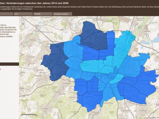
 |
| TU Munich main campus ArcGIS Online version |
One major issue of smart campus maps is to come up with solutions and standards that outline the workflow and specification of such a system. For this purpose, we need some models which explain the relations of geospatial data and their properties in detail. Therefore, we investigate different indoor data models for indoor areas such as CityGML, ESRI BISDM (Building Interior Space Data Model) and Indoor OSM, then customize and enhance them for a smart campus map. This conceptual model explains the geometrical relations between features in a smart campus map, their attributes and, additionally, the workflow from data collection to adaption in our model.
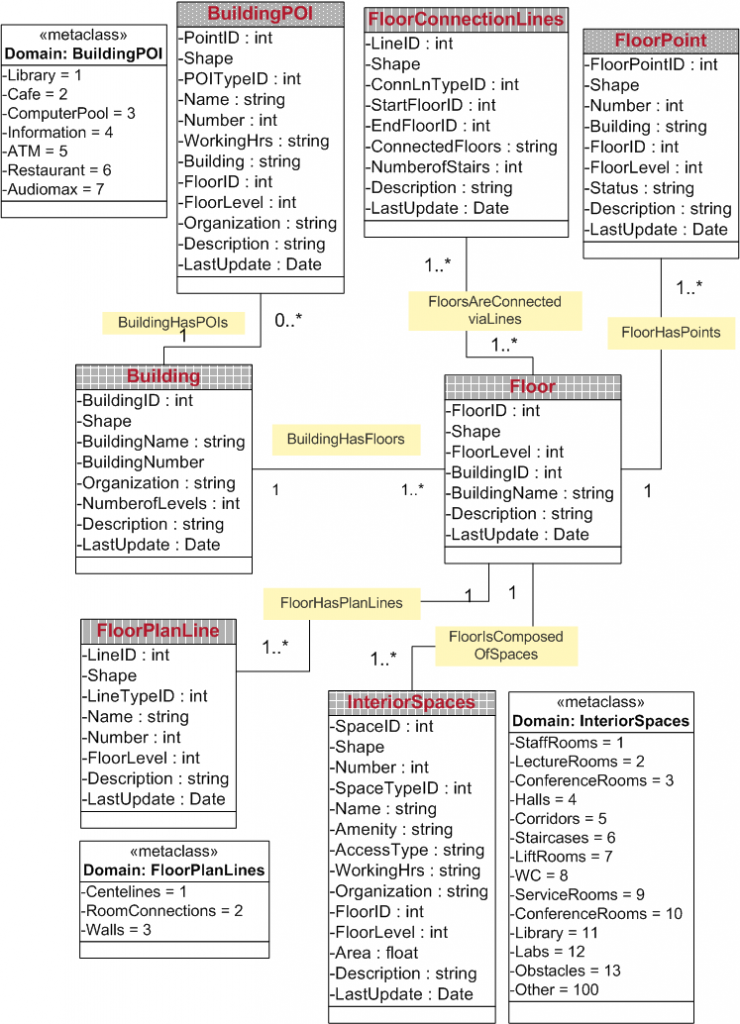 |
| Part of TUM Campus Indoor Data Model TUM buildings are mainly represented in the model by InteriorSpaces (polygon), FloorPlanLine (line) and FloorPoint (point) classes. The topological relationship and attributes of objects is explained in a detailed data model. |
For instance, the model shows how we are able to access a specific lecture room in one of the floors from a specific point outside the building via the shortest path. Another example is finding an alternative path if one of the lifts or stairs is under construction or out of service.
A reasonable indoor building model leverages according applications like on-campus routing among different buildings. Moreover, it shows how other entities like construction sites might influence the generated routes.
3D Smart Campus Map
One of the other objectives in a smart campus map is a fast loading and smart 3D visualization of interior spaces on small screens like mobile devices. However, a survey conducted among intended users (students) indicates the tendency to use 2D maps for mobile applications but in some cases 3D visualization is found to enhance the presentation of the campus map. For instance in the example below we rendered corridors and passages in each floor of the main building to provide fast orientation of users who are new in buildings.
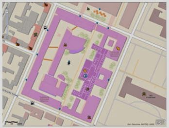
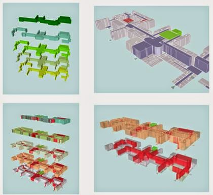 |
| Corridors and passages visualization in TUM Campus 3D map |
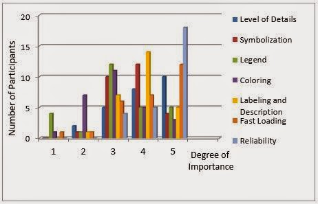 |
| Degree of importance for key factors in campus map/App |
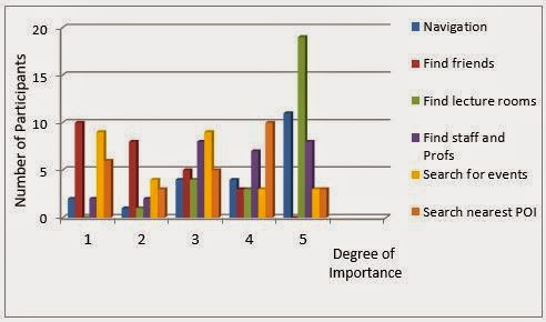 |
| Degree of importance for functionality in a digital campus map |
The concepts of a Smart Campus need to be developed using designed data models. Furthermore, the outcomes have to be represented in mobile apps and put into experiment. In this way we are able to test the system, get feedback from users, and enhance the standards. The ArcGIS API for mobile apps provides a proper platform for future work in this area.Shayan graduated in Geomatics and Surveying from Azad Tehran University, Iran in 2005. After his studies, he worked several years in the field of Geoinformatics and remote sensing in different national projects in Iran. In October 2011, he pursued the studies in International Master of Cartography in Technical University of Munich, which is a joint program with TU Vienna and TU Dresden. His Master’s thesis topic was entitled “Smart Campus Map”.