Do you want to flee the stuffy air of university? Then the Esri Summer Camp might be just right for you! On the beautiful island Föhr, we will be applying modern GIS-technology in the field and make unforgettable memories. But why should you apply and how can you do that? Read on!
We have been visiting the Nationalpark Schleswig-Holsteinisches Wattenmeer since 2007. Together with pupils, students and teachers as well as park staff we focus on diving deeper into Geographic Information Systems (GIS), while also gathering data in the tideland.
Why apply?
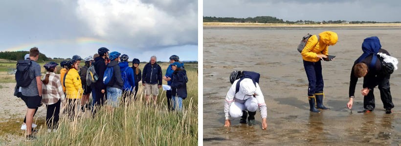
The Summer Camp is an unique opportunity that combines enhancing your GIS-skills with exploring the lovely island Föhr. In presentations and expeditions, we will learn about oyster beds, protection measures against storm surges and much more that will help you to locate your theoretical knowledge in the real world. Additionally, you will make unforgettable memories with other participants. Have a look at the impressions from the last years:
And some results from 2025:
The best? Esri covers the costs for accommodation, meals, and of course the professional program! You only need to pay for your trip to Föhr.
The program aims to include everyone that has anything to do with GIS in their studies, no matter if it is geography, hydrology or something else. At the GIS level, the week is designed for beginners as well as for advanced participants with basic ArcGIS-knowledge.
What’s the agenda?
Field Learning in the Wadden Sea
In different excursions we will learn about the tideland and why it is so important to protect it. Using mobile apps, like Field Maps and Survey 123, we will map seagrass and algae, sediment types, lugworms and snails. Due to the tides the Wadden Sea is a special and ever-changing habitat, which makes it an fascinating area to investigate.
Not only will we take a look at GIS, we will explore how such programs can be used in schools to facilitate interactive learning. Therefore, especially students aiming for an education degree will have an amazing chance to further their knowledge and gather significant experiences for their future jobs.
Improving your GIS-Skills
After the data collection, you will have time to process your data with different ArcGIS-tools. You can take a look at distribution areas, compare your data to the last 18 years and design your own map.
Besides analyzing the seagrass meadows in the area, you will have time to come up with your own project. You can use different apps to gather data, process it in ArcGIS Online or ArcGIS Pro and then visualize it in an interactive way, like a story map or instant app.
When you want to improve your skills in ArcGIS Online and ArcGIS Pro, are interested in topics concerning national parks, you have come to the right place!
When and where?

Arrival: 26.07.2026 till 6 pm
Departure: 31.07.2026 after 1 pm
Accommodation: Charlottenburger Heim in Wyk auf Föhr in shared rooms (Charlottenburger Heim in Wyk auf Föhr – Schullandheimverband Berlin e.V.)
Cost: only your travel expenses (Esri will cover the everything else.)
What do you need to bring to the table?
- basic knowledge of GIS
- some experience with digital media and programs like Word, Excel and PowerPoint
- ability to take walks through the tideland (around 5 h/8 km) and ride a bicycle (around 25 km)
If you have an end device, you are welcome to bring it. If you don’t own one, don’t worry, you can borrow one.
How can you apply?
To apply, you need to fill out the form below. It consists of your personal data and a short cover letter on why you want to participate and how this experience will impact your studies and future job. You don’t need to design a cover letter, just type it in the textbox. The cover letter will be the deciding factor on who gets to partake, as we only have space for 20 participants. You can apply to participate in the summer camp until 1. March 2026.
You will hear from us until 1. April 2026 whether you will be one of the participants in the Esri Summer Camp 2026.