GIS IQ Blog
  • Schule
  • Hochschule
  • Forschung
Kategorien
  • Forschung
  • Hochschule
  • Schule
Themen
ArcGIS Case Studies Digitale Bildung Dozierende eduGISchat Events GeoDev KarriereMitGIS Kartografie Lehrerhandreichungen Open Data Praktikum Projekte Ressourcen Schüler Smart Campus Smart Community Sommercamps Story Map Studierende Tutorial Unterricht Wettbewerb
  • Schule
  • Hochschule
  • Forschung
News
  • Hochschule

Unconference Session: Workshop on Citizen Science at #EsriEdUCEMEA

  • 1. August 2013
  • Grischa Gundelsweiler
Total
0
Shares
0
0
0
0
0
0

52°North and the Institute for Geoinformatics, Uni Münster (ifgi), will organize a workshop on Citizen Science in the field of mobility and environment during the Unconference session at the EMEAUC Education GIS Conference in Munich. We will focus on deriving environmental information from carborne sensor data, which can be collected using an Android app and published as anonymized open data via the www.enviroCar.org platform. enviroCar started as a study project at ifgi and will be further developed as an open source project at 52°North.

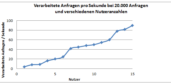
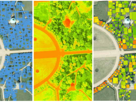
We will provide an overview of Citizen Science in general, the open enviroCar project in particular, and the challenges of crowdfunding Citizen Science projects. Together with TU Dresden and con terra, we will discuss the data and the open source tools used to collect, manage and analyze the enviroCar data. We will show how to use event-based processing tools, such as Esri’s Geoevent Processing Server and Safe Software’s notification server to handle enviroCar data streams. We will provide some outlook on integrating enviroCar data as Linked Open Data. We will show how to use R to implement spatial statistics and how to use Web Processing Services to integrate enviroCar data into any GIS environment. We will present ArcGIS Online as a platform to publish, enrich, and share information products both within the Citizen Science community and with local authorities and their citizens. Furthermore, we will demonstrate how to use the map.apps framework to produce rich and attractive web applications, which can easily be integrated into any web environment.

We are eager to discuss and exchange ideas with you! We are curious about your ideas and opinions on how to enhance and apply this concept in the fields of open government, science, and education.

If you would like to get more information about the enviroCar project, please have a look at www.envirocar.org and the enviroCar group at ArcGIS online. Would you like to get involved? Please subscribe to the envirocar@52north.org mailing list and check out the enviroCar repositories at GitHub. And stay tuned for any updates to the workshop agenda!

For more information, please contact Albert Remke a.remke@52north.org, author of this post.

– Grischa Gundelsweiler, Manager Education & Research, Esri Germany

Total
0
Shares
Share 0
Tweet 0
Pin it 0
Related Topics
  • Events
Grischa Gundelsweiler

Voriger Artikel
  • Hochschule

Esri Education GIS (Un)conference

  • 25. Juli 2013
  • Anna Lena Schwieger
Weiterlesen
Nächster Artikel
  • Hochschule

ArcGIS Online – wie performant ist die cloudbasierte Software wirklich?

  • 9. August 2013
  • Team Education
Weiterlesen
Dir könnte auch gefallen
Header für den Beitrag zum Graduate Program
Weiterlesen
  • Hochschule

Job-Tipp von Angelina Feigl: “Graduate Program” als Berufseinstieg bei Esri

  • Team Education
  • 28. April 2023
Weiterlesen
  • Hochschule
  • Schule

EsriKon Early Bird: Jetzt schon Tickets für Studierende sichern

  • Team Education
  • 20. April 2023
Weiterlesen
  • Hochschule

WWF Mapathon 2023 in Berlin: Studierende kartieren WWF-Projektregionen

  • Team Education
  • 5. April 2023
Weiterlesen
  • Hochschule
  • Schule

Komm mit in den Nationalpark Wattenmeer: Sommercamp für Lehramtsstudierende 2023

  • Team Education
  • 16. März 2023
Header für den Beitrag zu den Analysen im neuen Map Viewer
Weiterlesen
  • Hochschule
  • Schule

Neuer Map Viewer in Lehre und Unterricht – jetzt auch mit Analysen

  • Klaus Nakel
  • 1. März 2023
Weiterlesen
  • Hochschule

Für Studierende: WWF Mapathon Berlin (28.-31. März 2023)

  • Daniela Wingert
  • 27. Februar 2023
Titelbild der Esri MOOCs
Weiterlesen
  • Forschung
  • Hochschule

Esri MOOCs – erweitern euren GIS-Horizont

  • Team Education
  • 9. Februar 2023
Weiterlesen
  • Forschung
  • Hochschule

Geoinformatik Ingenieure – Computer Vision richtig lernen!

  • Team Education
  • 31. Januar 2023
GIS IQ Blog
  • Über uns
  • Impressum
  • Datenschutz
Lernen. Forschen. Entwickeln. Mit GeoIntelligenz!

Gib dein Suchwort ein und drücke Enter.